Skip to content


Moora Moora Reservoir and Rocklands Reservoir are Wimmera-Mallee System Headworks water storages in the Glenelg River system that contribute to the supply of water to towns and properties across the Wimmera, Mallee, Glenelg, Loddon, and Avoca catchments. Water for the environment is actively managed in the Glenelg River below Rocklands Reservoir. There are passing flow rules for the Glenelg River and upper Wannon River.

The priority reaches of the Glenelg River for deliveries of water for the environment are:

  • Rocklands Reservoir to 5-Mile Outlet (reach 1a)
  • 5-Mile Outlet to the confluence with the Chetwynd River (reach 1b)
  • Chetwynd River to the Wannon River (reach 2)
  • Wannon River to the tidal extent just below the confluence with Crawford River (reach 3)

Water for the environment in the Glenelg system is released from Rocklands Reservoir for reach 1a via the reservoir wall outlet and for reaches 1b, 2, and 3 via the 5-Mile and 12-Mile outlets.

The Glenelg River estuary benefits from releases of water for the environment to upstream reaches, but releases do not currently target the estuary. The Glenelg Hopkins CMA has investigated the importance of water for the environment in the Glenelg River estuary, listed as a heritage river reach and a site of international significance under the Ramsar Convention. Environmental flows provide landscape-scale benefits that support estuarine values.

Proportions of water entitlements in the Wimmera-Mallee System Headworks held by private users, water corporations and environmental water holders on 30 June 2020

Traditional Owners
Storage manager
Environmental water holder

System map

Environmental watering objectives in the Glenelg system

icon-objectives-fish
Protect, maintain and where possible enhance populations of endemic fish, including threatened and diadromous species
Landscape icon
Maintain deep pool habitats and connectivity along the river
Platypus icon
Maintain the platypus population
Plant icon
Maintain healthy and diverse mosaics of water-dependent vegetation (such as river red gums and Wimmera River bottlebrush)
Insect icon
Maintain a wide range and large number of waterbugs to break down organic matter and support the river’s food chain
Water icon
Maintain water quality for native fish, waterbugs, aquatic vegetation and other water-dependent animals

Environmental values

The Glenelg River starts in Gariwerd (the Grampians National Park) and flows to the sea through the Lower Glenelg National Park. The lower reaches of the Glenelg River are part of a landscape recognised as one of Australia’s 15 national biodiversity hotspots, and the Glenelg Estuary and Discovery Bay site was listed under the Ramsar Convention as a site of international significance in February 2018.

The Glenelg River supports a range of rare and unique aquatic life, including the endangered Glenelg freshwater mussel, Glenelg spiny crayfish, and a newly described species of river blackfish. It is also home to platypus and populations of native fish, including estuary perch, short-finned eel, tupong, and three species of pygmy perch, including the threatened variegated pygmy perch and Yarra pygmy perch. Some of these fish species migrate long distances to and from the Glenelg River estuary to complete their life cycles. Sand extraction currently occurs around the Casterton to Dergholm reaches to provide deep pools, habitats, and drought refuge areas, important to fish species and the macroinvertebrates that feed them.

Frasers Swamp is another important feature of the upper Glenelg system and is home to a healthy growling grass frog population. The swamp also meets the habitat requirements for the Australasian Bittern, and investigations are underway to determine if they use this habitat.

The Glenelg River supports a variety of streamside vegetation communities and species, including the endangered Wimmera bottlebrush. Streamside and floodplain vegetation comprises river red gum woodlands with paperbark, bottlebrush, and tea tree understorey.

Traditional Owner cultural values and uses

The Glenelg River, known as Bochara in Dhauwurd Wurrung, Pawur in Bunganditj, and Bogara in Wergaia-Jadawadjali languages, is a significant feature in the cultural landscape of south-western Victoria. The river features in the region's creation stories. Bochara-Bogara-Pawur (Glenelg River) continues to be an important place for Traditional Owners, who have inhabited the area for thousands of years, using the rich resources available along the river and the associated habitats.

In planning for environmental flows in the Glenelg River, several on-Country meetings have been held to increase Traditional Owner involvement in environmental watering. There has also been an increase in communicating operational changes to water deliveries. When planning for the Glenelg River seasonal watering proposal, the Gunditj Mirring Traditional Owners Aboriginal Corporation, Barengi Gadjin Land Council, Burrandies Aboriginal Corporation, and Glenelg Hopkins CMA have considered:

  • supporting the health of cultural heritage sites (such as scar trees, ring trees, stone structures, middens, and rock paintings) and native plants, which are sources of traditional foods and medicines
  • that improving the health and abundance of totem species and their habitat by delivering water for the environment also benefits Traditional Owners' spiritual well-being
  • supporting contemporary cultural events such as the Johnny Mullagh cricket match in March each year. A summer fresh is delivered to support environmental outcomes, but it also supports this event on the river.

Aboriginal Peoples across the Glenelg catchment have retained a strong identity and connection to the traditional lands for which they have custodial rights and responsibilities. Cultural values in the Bochara-Bogara-Pawur (Glenelg River) system align strongly with environmental values. Cultural values are holistic and interrelated: they are bound up with the health of the river system overall and the Country of which the river is part. Traditional Owners' well-being is connected to the health of the river and of Country.

Gunditjmara Traditional Owners have identified that it is a priority to spend time on the river and increase cultural practices and connection to Country. They have highlighted the importance of increasing ceremonial and on-Country gatherings along the river, including at Casterton and the Glenelg Estuary.

The Glenelg River Yarns website was launched in late 2021 as part of the Glenelg River Cultural Flows project. The website shares cultural values and stories on a virtual tour and welcomes all visitors to Country.

Figure 4.2.2 Glenelg River Environmental Flow Seasonal Calendar

Figure 4.2.2 Glenelg River Environmental Flow Seasonal Calendar

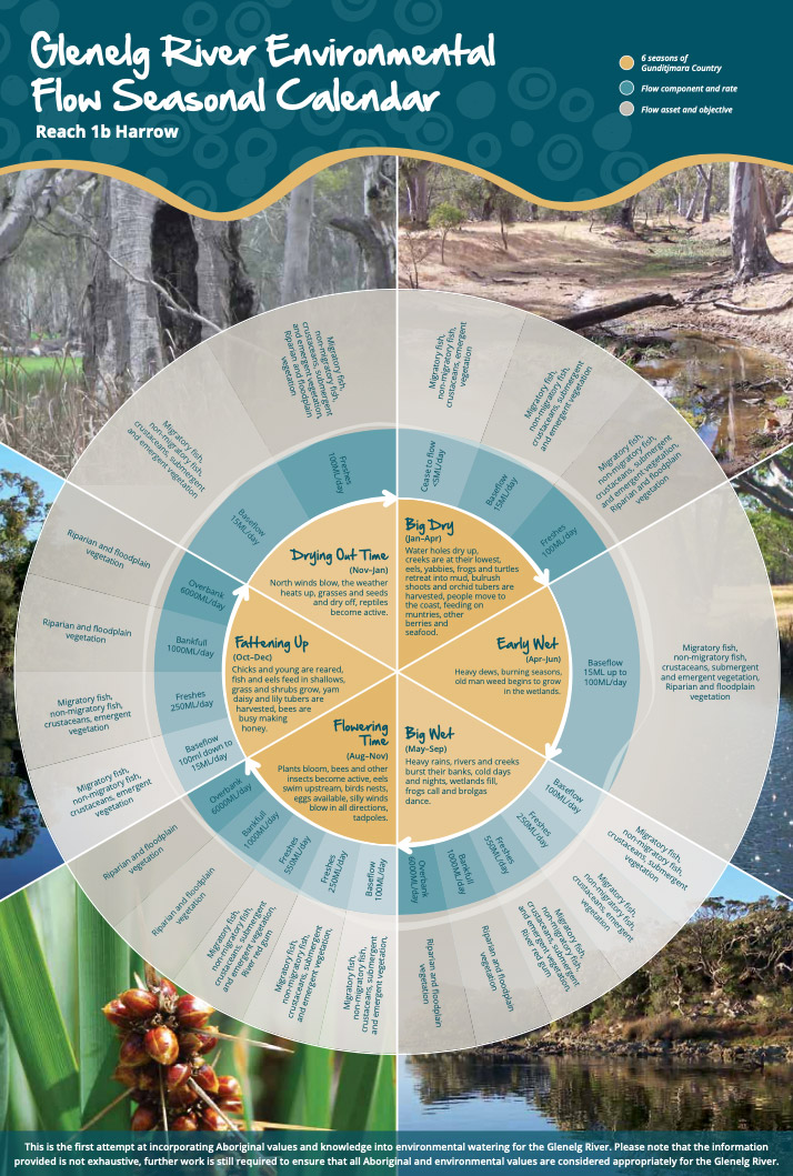
Figure 4.2.2 was produced by the Gunditj Mirring Traditional Owners Aboriginal Corporation and describes the six seasons of Gunditjmara Country. The northern part of the river upstream of the Harrow area is in Jadawadjali Country, and the southwestern part of the system is in Boandik Country. The calendar describes the six seasons alongside flow components for reach 1b of the Glenelg River – from 5-Mile Outlet to Chetwynd River – and aligns them with corresponding watering effects and objectives. The calendar reflects the seasonal flow conditions that all Traditional Owner groups recognise.

The value of the calendar is in its clear visual depiction of Traditional Owners' knowledge, developed over many generations, of how varying flows correspond to seasonal conditions and broader environmental patterns. The six seasons will eventually be embedded in environmental flow recommendations and scenario planning in future years.

Increasing the involvement of Traditional Owners in the planning and managing environmental flows and ultimately providing opportunities to progress towards self-determination within the environmental watering program is a core commitment of the VEWH and the Glenelg Hopkins CMA. This is reinforced by a range of legislative and policy commitments, including the Water Act 1989, the Victorian Aboriginal Affairs Framework, the 2016 Water for Victoria, and in some cases, agreements under the Traditional Owner Settlement Act 2010.

Where Traditional Owners are more deeply involved in the planning and/or delivery of environmental flows for a particular site, their contribution is acknowledged in Table 4.2.1 with an icon. The use of this icon is not intended to indicate that these activities are meeting all the needs of Traditional Owners, but is incorporated in the spirit of valuing their contribution and indicating progress towards deeper involvement.

Billabong icon

Watering planned and/or delivered in partnership with Traditional Owners to support Aboriginal cultural values and uses

The timing of the summer/autumn fresh is planned to support the annual Johnny Mullagh Cup cricket match between Gunditj Mirring and Barengi Gadjin Traditional Owners.

Social, recreational and economic values and uses

In planning the potential environmental watering actions in Table 4.2.1, the Glenelg Hopkins CMA considered how environmental flows could support values and uses, including:

  • water-based recreation (such as canoeing and fishing)
  • community events and tourism (such as the Johnny Mullagh Cup and visitation)
  • socioeconomic benefits (such as for diverters for stock needs and domestic use: water levels and water quality can rely on the delivery of water for the environment, particularly in summer).

If the timing or management of planned environmental flows may be modified to align with a community benefit, this is acknowledged in Table 4.2.1 with the following icons.

Fishing icon

Watering planned to support angling activities

Kayak icons

Watering planned to support water sports activities (e.g. canoeing)

Camping icon

Watering planned to support peaks in visitation (e.g. camping or other public activities on long weekends or school holidays)

Environmental flow releases support the spawning and recruitment of popular angling species like estuary perch and bream. Local anglers continue to report increased fish activity associated with the delivery of freshes, improving fishing opportunities in the river. Releases also support numerous fishing competitions, including the Casterton angling club.

The planning of the summer fresh improves accessibility, water quality and amenity for canoeists planning trips on the Glenelg River over the summer holiday period.

Summer and spring freshes improve conditions at popular riverside campgrounds in the upper reaches of the Glenelg River, including Fulham Reserve near Balmoral and the Johnny Mullagh Reserve at Harrow.

Scope of environmental watering

The term ‘environmental watering’ refers to the active delivery of held environmental water to support particular environmental objectives by altering the flow in a river or the water level in a wetland. While other terms are sometimes used to describe the delivery of environmental water, ‘environmental watering’ is deliberately used here and in seasonal watering statements to ensure consistency in the legal instruments that authorise the use of water for the environment in Victoria.

Table 4.2.1 describes the potential environmental watering actions in 2023-24, their expected watering effect (that is, the intended physical or biological effects of the watering action) and the longer-term environmental objectives they support. Each environmental objective relies on one or more potential environmental watering actions and their associated physical or biological effects.

Table 1 Potential environmental watering actions, expected watering effects and associated environmental objectives for the Glenelg River

Potential environmental watering action

Expected watering effects

Environmental objectives

Winter/spring low flow in reach 1a (60 ML/day or natural during June to November)

  • Maintain water quality for fish and waterbugs
  • Wet aquatic vegetation to maintain its condition and prevent encroachment by terrestrial species
  • Maintain shallow-water habitat for fish, waterbugs and platypus
Fish icon Plant iconPlatypus iconWater drop icon

Winter/spring low flow in reach 1b (100 ML/day or natural during June to November)

Winter/spring low flow in reach 2 (160 ML/day or natural during June to November)

Winter/spring low flow in reach 3 (400 ML/day or natural during June to November)
  • Wet benches to increase habitat and allow widespread fish passage.

Fish icon

Winter/spring fresh(es) in reach 1b (one to five freshes of 250 ML/ day for one to five days during June to November/Big Wet to Fattening Up1)

  • Wet benches to improve the condition of emergent vegetation and vegetation on the riverbanks to support recruitment and growth and maintain habitat diversity
  • Provide adequate depth for fish passage and cue fish movement
  • Encourage female platypus to select a nesting burrow higher up the bank to reduce the risk of greater flow later in the year flooding the burrow when juveniles are present
  • Scour sand from pools to improve the quality of fish habitat

Fish iconMountain iconsPlatypus iconPlant icon

Winter/spring fresh(es) in reach 2 (one to five freshes of 300 ML/day for one to fivedays during June to November)

Summer/autumn low flow in reach 1a (10 ML/day or natural during December to May)

Camping iconKayak iconsFishing icon
  • Protect against rapid water-quality decline over the low-flow period
  • Maintain edge habitats, pools and shallow-water habitat for fish, waterbugs and platypus
  • Maintain a near-permanent wetted stream channel to promote the growth of in-stream vegetation and prevent encroachment by terrestrial plants

Fish iconWater drop iconPlatypus iconPlant iconInsect icon

Summer/autumn low flow in reach 1b (15 ML/day or natural during December to May/Big Dry to Early Wet1)

Camping iconKayak iconsFishing icon

Summer/autumn low flow in reach 2 (25 ML/day or natural during December to May)

Camping iconKayak iconsFishing icon

Summer/autumn low flow in reach 3 (80 ML/day or natural during December to May)

Camping iconKayak iconsFishing icon

Summer/autumn freshes in reach 1a (one to two freshes of 60 ML/day for two to three days during December to May)

Billabong iconCamping iconKayak iconsFishing icon
  • Flush fine silt from the stream bed and hard substrate to improve the quality of the fish and waterbug habitat
  • Wet emergent vegetation on the lower banks to improve its condition and prevent the encroachment of terrestrial species
  • Flush pools to improve water quality and lower temperatures
  • Provide sufficient flow to allow native fish and platypus to access habitat

Fish iconPlant iconPlatypus iconMountain iconsWater drop iconInsect icon

Summer/autumn fresh(es) in reach 1b (one to two freshes of 100 ML/day for two to three days during December to May/Big Dry to Early Wet1)

Billabong iconCamping iconKayak iconsFishing icon

Summer/autumn fresh(es) in reach 2 (one to two freshes of 150 ML/day for two to three days during December to May)

Billabong iconCamping iconKayak iconsFishing icon

Summer/autumn fresh(es) in reach 3 (one to two freshes of 150 ML/day for three days each or natural during December to May)

Billabong iconCamping iconKayak iconsFishing icon

1See the Glenelg River Environmental Flow Seasonal Calendar in this section.

Page last updated: 01/12/22