About the region
Within the Victorian Murray system, there are many significant floodplains and wetland systems covering the North East, Goulburn Broken, North Central and Mallee CMA areas. They are sites of significance for Traditional Owners, with tangible and intangible cultural connections dating back many thousands of years and continuing to the present day. The Barmah Forest, Kerang wetlands and the Hattah Lakes are internationally recognised Ramsar-listed sites due to the significance of their wetland types and the abundance and range of waterbird species that use them. Many other wetlands in the system are either nationally or regionally significant.
Water for the environment can be supplied to the Victorian Murray system from a range of sources. These include entitlements held by the VEWH, which includes those held on behalf of the Living Murray program and the Commonwealth Environmental Water Holder (CEWH); reuse of return flows; and in some instances, use of operational water en route. The source of the water used for individual watering actions and the ability to deliver all watering actions will depend on water availability, water commitments by other environmental water holders and operational requirements. As a result, the following Victorian Murray system sections do not specify the expected availability of water for the environment.
Victorian Murray system water availability
In 2021-22, allocations against high-reliability water shares reached 52 percent in August and 100 percent in October. Low- reliability water shares began receiving allocations in December and reached their full allocations in February. This is the first time Murray seasonal determinations reached maximum availability since the introduction of the current entitlement products in 2007. Spills from Hume Dam resulted in the deduction of most spillable carryover from 2020-21, as of 11 May 2022.
Prolonged periods of declared unregulated flow conditions in the Murray River enabled access to unregulated components of environmental entitlements and access to River Murray Unregulated Flows (RMUF). Victorian unregulated entitlements were primarily used to meet Murray floodplain demands at Gunbower, Hattah and the Lindsay Mulcra Wallpolla islands icon sites in spring, while RMUF was used for Murray River channel (Hume to the Coorong) water actions agreed by the Southern Connected Basin Environmental Watering Committee (SCBEWC). The strong resource position allowed the Barmah-Millewa Forest Environmental Water Account to be repaid much earlier in the year than normal, and it was used in combination with other holdings to meet Barmah-Millewa Forest demands in late winter and spring.
Significant volumes were released from the Snowy system to the Murray system in 2021-22, which is likely to result in additional River Murray Increased Flows (RMIF) being available in the Murray system in May 2022. SCBEWC has the first option on RMIF, and it accepted 112,000 ML that it can use to meet Murray demands from June 2022 onwards and/or carry over into 2022-23.
Total water availability for the environment was high in 2021-22, with sufficient supply to meet planned Victorian Murray system demands and carryover needs for 2022-23. The high water availability allowed the VEWH to sell up to 12,000 ML of its allocation in autumn.
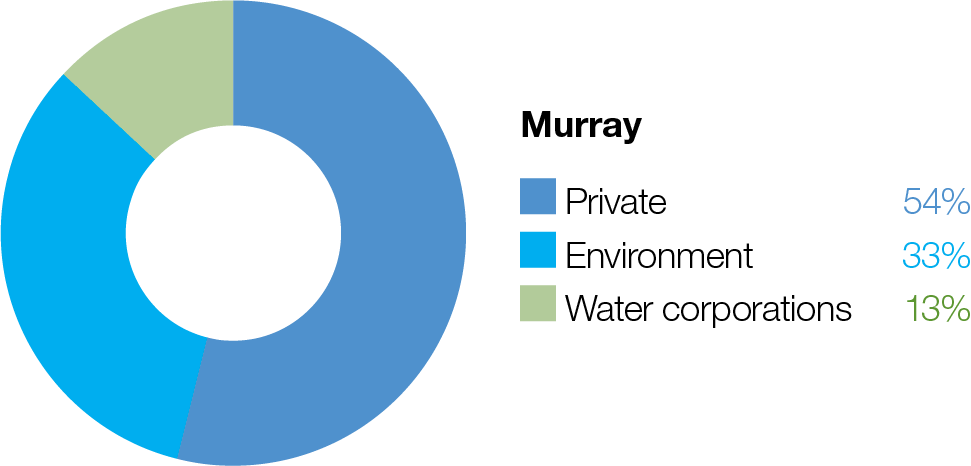
Proportion of water entitlements in the Murray basin* held by private users, water corporations and environmental water holders on 30 June 2020.
*the Murray basin includes Barmah Forest, Gunbower Creek and Forest, Central Murray Wetlands, Hattah Lakes, Lower Murray Wetlands, and Lindsay, Wallpolla & Mulcra systems.
View the current seasonal watering plan for the rivers and wetlands that make up the Victorian Murray System: